This is the story of how the world travels of a 19th century explorer, two bar magnets and the World War II hunt for enemy submarines led to the invention of the portable fluxgate magnetometer. And how that invention, in turn, led to the “magic profile,” a powerful piece of evidence for the theory of plate tectonics.
In the 1950s, the idea that Earth’s continents might be on the move was largely ridiculed, and the seafloor was still mostly a mystery. But that was about to change: In the aftermath of World War II and its naval battles, researchers suddenly had powerful new tools, such as submersibles and sonar systems, to map and probe the seafloor in greater detail than ever before. Among these new technologies was a small, portable device known as a fluxgate magnetometer.
Magnetometers, devices that measure Earth’s magnetic field, were far from a new technology at that point. Scientists had known for centuries that Earth produces its own magnetic field; sailors used compasses to navigate by it. But the strength of that field was puzzlingly inconsistent from place to place.
During his travels around the globe in the early 1800s, the German explorer and geographer Alexander von Humboldt collected measurements of Earth’s magnetic field at different locations, noting that the field’s intensity increased farther from the equator. Those variations led Humboldt in 1831 to initiate a coordinated effort to precisely measure this magnetic intensity around the world. Among others, he enlisted the help of German mathematician Carl Friedrich Gauss in this effort.
Gauss delivered. In 1833, he reported devising the first magnetometer, which could measure the absolute intensity of Earth’s magnetic field at any location. His magnetometer was deceptively simple, consisting of two bar magnets, one suspended in the air by a fiber and one placed a known distance away. The deflection of the suspended magnet from geomagnetic north depends on both the intensity of Earth’s magnetic field and the pull of the second bar magnet. These measurements succeeded in providing the first global maps of Earth’s magnetic field strength.
But by World War II, the U.S. Navy was looking for even more precise measurements of magnetism. Specifically, the Navy wanted to be able to map very small anomalies in Earth’s magnetic field — anomalies that might be due, for example, to the presence of metallic objects, such as submarines, beneath the surface of the water.
In 1936, scientists designed such a precise sensor, called a fluxgate magnetometer. In a fluxgate magnetometer, instead of a spinning needle like in a compass, a bar of iron is wrapped in two coils of wire. One coil carries an alternating current along the length of the iron core, tinkering with the core’s magnetic state, first saturating it with magnetism and then desaturating it. When in the unsaturated state, the core can pull in an external magnetic field, such as Earth’s. When saturated, the core pushes the external field back out. The second coil is there to detect those changes in magnetism — and along the way can very precisely measure the strength of the external field.
But to use this device to look for submarines, it would have to be portable, able to be mounted on an airplane. That’s where Russian-born geomagnetist Victor Vacquier enters the story. Vacquier was at the Pittsburgh-based Gulf Research Laboratories, an arm of Gulf Oil, where, for several years, he had been hard at work on a portable version of the fluxgate magnetometer.
In 1941, successful tests of Vacquier’s device drew the attention of the Navy, which saw the defense potential of his device. With naval funding, fluxgate magnetometers were airborne by December 1942 and busily hunting for enemy submarines.
After the war, scientists were eager to see what this precise, portable magnetometer could reveal about the seafloor. Oceanographers refitted the device so it could be towed behind research vessels as they swept back and forth across the oceans. During the 1950s and early 1960s, Vacquier (by then at Scripps Institution of Oceanography in La Jolla, Calif.) and other researchers began using the fluxgate magnetometer to measure and map magnetic anomalies preserved in the seafloor rocks.

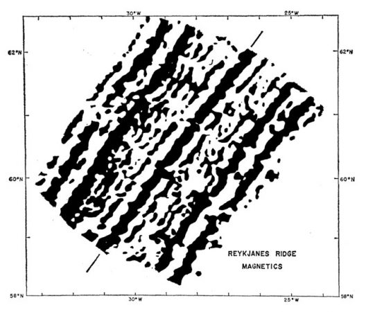
The maps revealed a curious zebra-stripe pattern of magnetic polarity on the seafloor, something never seen in continental rocks. In this pattern, bands of rocks with normal polarity — the north-south orientation corresponding to that of Earth’s current magnetic field — alternated with bands of reversed polarity. These stripes, scientists hypothesized, might be due to Earth’s magnetic field reversing direction from time to time.
Even more tellingly, the zebra-stripe pattern turned out to be symmetrical on either side of the long, snaking underwater mountain chains known as mid-ocean ridges. That pattern became one of the most powerful lines of evidence for the hypothesis of seafloor spreading, the idea that as Earth’s crust pulls apart at the mid-ocean ridges, magma wells up to form new ocean crust. As the new crust hardens, its iron-bearing minerals align with the current orientation of Earth’s magnetic field, and the hardening rocks become a new stripe in the pattern.
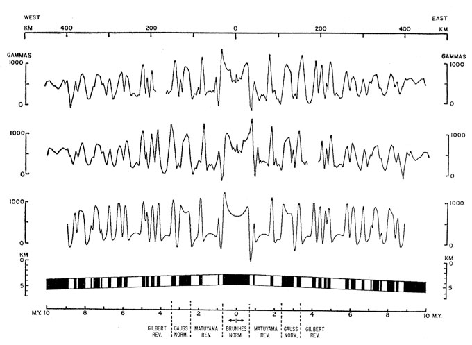
In 1968, about 100 earth scientists met for what was about to become a seminal moment in the story of plate tectonics. At the meeting, a two-day symposium held at the Goddard Institute for Space Studies in New York City, geologists Walter Pitman and James Heirtzler of Lamont-Doherty Earth Observatory in Palisades, N.Y., presented a profile of magnetic anomalies they had measured in 1966 from aboard the R/V Eltanin.

The symmetry on either side of the Pacific-Antarctic Ridge was crystal clear, so perfect that it became known as the “magic profile.” This profile, made possible by a series of inventions over the previous century that culminated in a portable, precise magnetometer, became one of the most convincing lines of evidence for seafloor spreading — and ultimately, for the theory of plate tectonics.
"device" - Google News
July 02, 2021 at 07:00PM
https://ift.tt/3qFb07U
A WWII submarine-hunting device helped prove the theory of plate tectonics - Science News Magazine
"device" - Google News
https://ift.tt/2KSbrrl
https://ift.tt/2YsSbsy
Bagikan Berita Ini


0 Response to "A WWII submarine-hunting device helped prove the theory of plate tectonics - Science News Magazine"
Post a Comment